Home » Posts tagged 'mt. kilimanjaro'
Tag Archives: mt. kilimanjaro
Kilimanjaro – Uhuru Peak Top of Africa Oct 2012
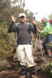
 Earlier this year, 6 of us decided to attempt hiking Mt. Kilimanjaro and on Oct 19th, all six of us reached Uhuru Peak, Africa’s highest point which stands at 5895m / 19340 ft. above sea level. We reached the summit just before sunrise at 6 AM and spent some time admiring the views from the summit – it was cold, by some reports about -15 Celsius and about 20 minutes was all we could spend up there. Here is a day-by-day account of our adventure. We used 7summits/Zara as our tour operator and selected the Lemosho route for our ascent which took 7 days. We were well acclimatized to the altitude and did not experience any sickness. I am sure our daily dose of Diamox helped a great deal. Some key facts about our trip:
Route: Lemosho – 7 nights/8 days
Crew: 3 Guides (Bruce, Faraja, Adam) along with an assistant guide Babu; 16 porters and 1 cook and 2 assistant cooks and the amazing all rounder Ambrose!
Tour operator: 7 Summits / Zara
Day 1: Somewhere before Lemosho Gate to Big Tree Camp
Hike start: 220 PM ~6000 ft elevation
Hike end: 800 PM 9000 ft. elevation
Started off with a bang – unfortunately not the right kind of bang! We were picked up at our hotel in what used to be an Italian military truck around 830AM on October 9th. It was about a 3 hour drive to the Londorossi Park Gate, where we got our permit and the crew had to go through the painful process of weighing all the gear and goods which we were going to take up the mountain. Tanzanian park officials seem to follow strict rules for Garbage in/Garbage out for the mountain. Our team of 6 had a crew of 19 which included porters and cooks. While, the permit process was going on, we had a boxed lunch to consume – bread, boiled egg, pineapple juice and fruit. After we were registered, we had another 90 minute drive to the start of the Lemosho Gate. We got our permits and started around 1 pm and almost immediately it started raining pretty hard. The ‘roads’ here are unpaved and as we ascended, the trucks 4 wheel drive system was put to work. The old engine worked hard to keep on the dirt track and we trudged along until we reached a very slippery section around 220 pm, The driver attempted his best to keep the truck going but we slid sideways and almost toppled over.  The truck was stuck but fortunately no one was hurt. This was the abrupt start to our hike. Some of us had dozed off in the truck and the slippery ordeal was a rude interruption. We now had a 2 hour hike to the trail head at Lemosho Gate. At 230 pm, we started hiking up in the rain. The trail was slippery and muddy and make hiking uphill really tricky. We entered the base of the rain forest and around 615pm had to start using our head lamps as it got quite dark. We reached the Big Trees camp (~9000 ft altitude) around 8 pm.
It was a welcome sight to see the tents and look forward to getting some food and sleep. The camp was quite crowded but we could not appreciate the beauty because of the darkness. We woke up the next morning to a bit of sunshine and were able to appreciate the beauty of the camp.
Here is an early morning shot at the camp:

Day 2: Big Trees Camp to Shira I
Hike start: 820 AM 9000 ft elevation
Hike end: 230 PM 11500 ft. elevation
We woke up pretty early and had tea at about 630 AM. The tea and coffee here is locally grown and quite good. After breakfast, we packed up and left the camp at around 820 AM. The hike took us through the rain forest and the weather was cool but humid.  We were told that these forests have quite a few animals – various types of monkeys and sometimes even leopards are spotted – we did not have any luck with wildlife sighting. Only exception, we did see a blue monkey – it is not exactly blue but really don’t know why it gets that name. We passed the 10,000 feet mark and took a short break. Soon after we resumed our hike, it started raining. The rain forest is quite dense and very pretty. The picture shows trees with thick moss on the branches.
We hiked in heavy rain for about 4-5 hours to reach Shira I camp.
Unfortunately, this was a miserable day and the trail was very muddy. We got to camp and the rain tapered off. It felt really good to reach the camp and soak in some sunshine. Shira I is above the tree line but there still is sparse vegetation up until 13,500 feet.
We talked to some other hikers – a group from Germany and a few others. One of the ladies in the group is already experiencing headaches – an early sign of altitude sickness. We rested for a bit, chatted in our dinner tent and then had an early dinner. The temperature was around freezing and we were surely in for a cold night.
We were able to get some of our clothes dry and have been assured of a sunny forecast for the morning.
Day 3 is an easy day with a short hike to Shira 2. Several hikers choose to skip this camp and do the Lemosho route and summit on the 6th day. We chose the 7 day plan to allow for proper acclimatization and increases the chances of a successful summit.
Mehboob took this shot after dinner. We all were in our tents with our headlamps on. I think this is the best shot of the trip:

Day 3: Shira I to Shira II
Hike start: 930 AM 11500 ft elevation
Hike end: 130 PM 12600 ft. elevation
I had disturbed sleep through the night but having woken a up a few times through the night, I got the opportunity to see the amazing night sky. Unfortunately, I don’t have any pictures but I am sure no picture could do justice to what I saw – stars like you can reach out and touch. I have never seen something like that. I woke up early around 530 AM and the view from the tent was a majestic Mount Meru rising above the clouds. We only had a 3-hour hike to Shira 2 camp with a modest elevation gain. We got to Shira 2 camp early afternoon. After lunch we rested in our tents and did a short evening hike with about a 400 ft altitude gain. Some of us experience the first signs of altitude sickness – headaches. We discussed the use of Diamox with our guide and all of us started our daily dose. We retired early for the evening. Day 4 is a big day for acclimatization and had a long tough hike.
Day 4: Shira II to Barancco Camp via Lava Tower
Hike start: 900 AM 12,600 ft elevation
Hike end: 530 PM 13,000 ft. elevation
After breakfast, we took a few pictures of Mt. Meru and started out our hike to Lava Tower. The view of Mt. Meru was majestic, rising to a height of about 16,000 feet above the clouds.

We started our hike around 9 AM with a plan to take a lunch break at Lava Tower.
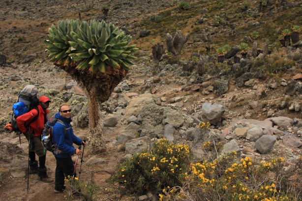
Lava Tower’s elevation is 15,200 feet and this was higher than I have ever gone before. The views were amazing. Every camp has been more beautiful than the previous camp. We were well above the tree line and the vegetation was sparse. As we started hiking, our views were obstructed by fog that rolled in about 30 minutes into the hike. It was a cold day. We stopped for lunch around 1 pm right at an elevation of 15000 ft. with Lava Tower in sight. After a quick lunch, we continued our hike to Lava Tower and got to the about 15,200 feet in about 30 minutes. 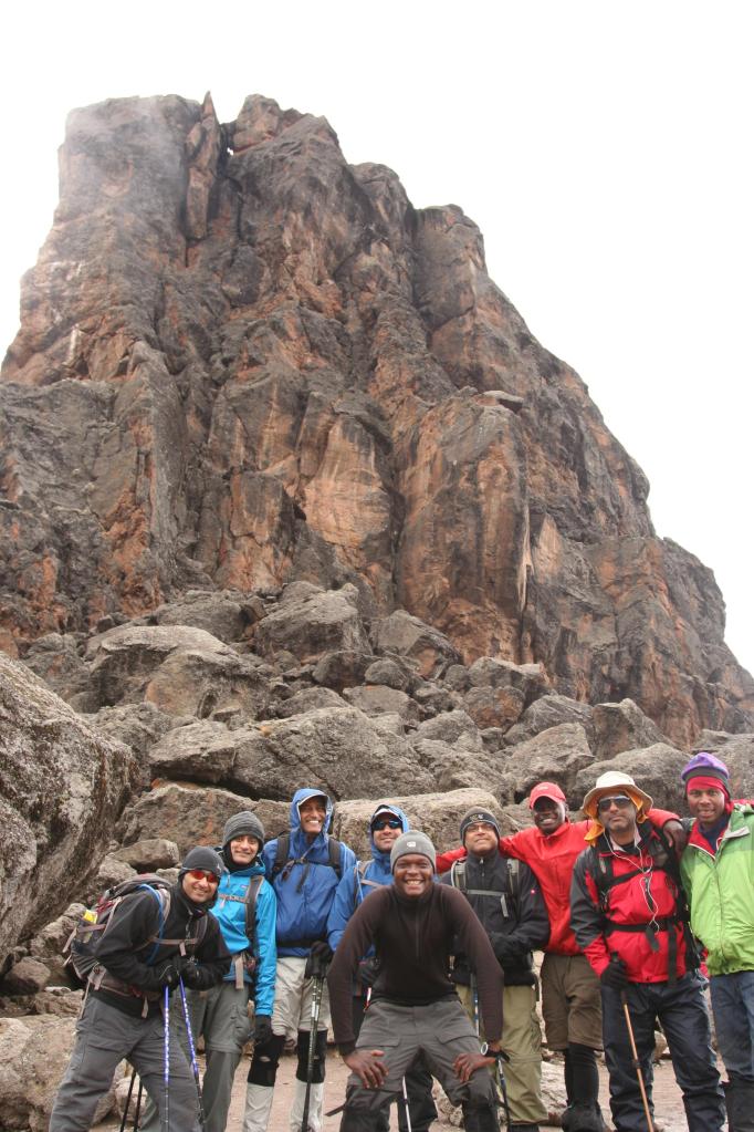 We met several other hikers but ended up talking to a group of 4 young women who had been in Tanzania for the past 5 weeks doing charity work – teaching English and Nursing. I will never know if it was the Diamox helping me or I did not feel any altitude sickness. It took us about 3 hours to hike down to Barranco camp. The vegetation was something that we have never seen before. The landscape had weird trees called Senacio Kilimanjari and other shrub like plants called Libera Dekka. The Senacio trees live for over 100 years – it seems each branch takes about 25 years to mature. Barranco camp is almost at the same elevation at Shira 2. We finished dinner and sat up chatting for a bit and then decided to retire for the night.
The first thing on day 5 was going to be a steep ascent through what is called the Barranco wall. Our guide, Bruce assured us that it was going to be easy.
Day 5: Barancco Camp to Karanga Camp
Hike start: 830 AM 13,000 ft elevation
Hike end: 130 PM 13,500 ft. elevation
The day started with a challenging hike up the Barranco Wall, a 1000 feet elevation gain with switchbacks, some of which required the use of hands. This was the only part where we did not use our hiking sticks. The path was tough to navigate at times and we were all amazed at how the porters maneuver the precarious points. This part of the trail reminded us of the Angel’s Landing Trail in Utah. Angel’s Landing was a bit more dangerous as it had some sheer drops – no such thing here. After climbing we wall, we were at a plateau with gorgeous views of Mt. Meru on one side and our first good view of the glacier on the other. We spent about 45 minutes  here, resting and taking pictures . An interesting observation – we saw the Barranco Camp while hiking up the Barranco Wall and about 30 minutes into our hike, the camp was left clean – no tents, no garbage and no sign of the fact that there were over 100 people that camped there the night before. So it seems the ‘Garbage in/Garbage out’ policy seems to be taken very seriously.
After our photo session, we started our descent into the Karanga valley. The hike was moderately tough and certain sections with loose gravel posed some slipping hazard and putting the padding on our rear ends to good use.
The trail meandered through the valley and the last hour of our hike for the day had us on a steep ascent to Karanga camp.
Karanga Camp was quite a barren camp and with a good view of peak. We had plenty of time to rest in the evening. We met up with a group of Canadians – who gave us some ideas for our next adventure – The Annapurna Circuit in the Himalayas. We met a lot of interesting people on the hike and kept bumping into the same groups every day. It was interesting to see 3 couples enjoying the hike as a part of their honeymoon. There was a group of 9 poeple from Norway; all 9 of them above the age of 62 with the oldest one being 67. We also met a couple who was dating along with the young man’s mother – don’t know if it was a test for the would be mother-in-law or the would be daughter-in-law or a test to see if the relationship would move forward. Day 6 for us will have us either camping at Barafu camp or going an hour and half longer and getting to Kosovo camp. Kosovo camp is not an official camp and if we did get the opportunity, we would save an hour on our summit day climb.
Day 6: Kosovo Camp to Summit
Hike start: 1215 AM 16,200 ft elevation
Peak: 600 AM 19,384 ft. elevation
Hike End: 400 PM 10,000 ft elevation Mkweka Camp
High altitude has some interesting side effects. I have had weird dreams every night – this is apparently quite common. However, we had acclimatized well by this day, given our ascent to Lava Tower (15,200 feet). Per our guide our food has changed every day to cater to the next day’s hike. Our carbohydrate intake had increased significantly.
We started our hike at 8 AM and reached Barafu camp at 1145 AM. Bruce had made it here before us and had already made arrangements for us to camp at Kosovo camp. We have chicken and spaghetti for lunch and started climbing to get to Kosovo camp. We decided to rest for a bit and have an early dinner at 6 PM. After dinner, we attempted to sleep for a few hours. It was very cold and I found it quite difficult to sleep. I am sure it had something to do with the altitude as well. After a few hours of tossing and turning, we decided to wake up and prepare for the long hike ahead. We woke up 1130 pm, had some tea and cookies. We started our summit ascent hike at 1215 AM. It was bitter cold. All of us were dressed up in multiple layers. I had 5 layers on the top and 3 layers at the bottom, gloves and balaclava to cover the face. We were warm enough but all of us had really cold hands and feet. We had 3 guides with us and were walking switchbacks in pitch dark and extremely steep gradient. Our headlamps provided a very focused view – feet of the person in front of us 🙂 The climb was the hardest between 3 AM – 4AM – that is the time when sleep hit all of us. It was hard to stay awake despite the grueling hike. We were delighted when we reached Stella Point at 445 AM. We had some tea and took a break for a few minutes. From Stella Point, the gradient eased up. We started seeing the orange glow of the upcoming sunrise in the horizon just as we reached the summit at 6AM. It was really cold and we did not feel like getting our hands out of our gloves. We ended up waiting for a few minutes and saw a spectacular sunrise. The sunlight lit up the glacier next to the summit and it was an amazing sight. We were all very happy to have made it to the summit without any illness or injury.

I think all our preparation helped us in getting up to the top of Uhuru Peak. We made a fun team and were always in good sprits (except when it was raining the first two days :)). At 645AM, we started making our way down from the Peak to Kosovo camp. The downhill was slipping and sliding more than it was hiking. The trail has loose gravel called scree which makes it very tricky to come down. The only option is to dig your heels first and start walking and most importantly be prepared to fall! I found out that even though I cannot ski, I can scree pretty well.
We made it down to Kosovo camp by 840 am and rested a bit. After having some lunch we packed our gear and began the trek down the mountain. Our plan was to get to Mweka hut before the evening, camp there for the night and start out early morning to get back to Moshi. We got to Mweka Hut around 4 pm.
